Snapshot of Early Indicator of Strategic Military Program in the Arctic
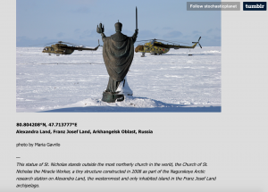
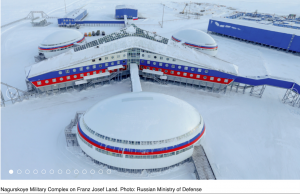
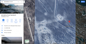
After the text below, see three images, Top, Middle and Bottom, the top image showing a likely early indicator of Russian strategic military intent in the Arctic. *To see the images up close with clarity, right click and view images in new window.*
As the U.S. was closing bases and not building icebreakers, the Russians were doing the opposite. Here is some helpful 2019 imagery of Russia’s strategic expansion in the Arctic making note of how expensive the Arctic expansion must be. Indeed, Russia clearly found the resources needed to leap ahead of the United States in the Arctic.
Top Image: See below: The top photo is found on the Tumblr blog “Stochastic Planet” with a link to Russian scientist Maria Gavrilo’s defunct Panoramino site, showing a statue of St. Nicholas with a sword at a chapel built in 2008 for a “Research Station” according to her captured Panoramino comments, showing coordinates 80.804208°N, 47.713777°E Alexandra Land, Franz Josef Land, Arkhangelsk Oblast, Russia. Assuming Gavrilo was the photographer she snapped a photo of her military ride (two Russian military helicopters) with a chapel statue visible, two elements of Russian nationalism in Putin’s remaking of the quasi-imperial KGB-heavy autocracy. In 2008, the year the chapel and what Gavrilo calls the “research station” was built, President Putin ordered the invasion of Georgia, signaling Moscow’s increasingly aggressive military agenda. The site Gavrilo calls a “research station” had also been a Soviet military airfield built in the 1950s, now upgraded and operational.
Dr. Gavrilo’s publications are largely on Arctic ecology, a necessary consideration given the Soviet history of polluting the Arctic and the need for biological understanding of the sustainability of an Arctic base for people. If the Arctic research was preparatory for building the base, not indicated by the Russian scientist in her photo (who by the way was part of international teams of scientists working in the Arctic) then planning began roughly 5-6 years before the start of the build-out.
Dr. Gavrilo’s online presence indicates her participation in scientific research among colleagues from Arctic powers and NATO nations.
Middle Image: See below: The middle photo is from the Russian Ministry of Defense, showing the same area after completion in 2017. Here a major Arctic military base was completed in less than 10 years from the first photo. The area was an old military airfield, now a Russian Air base. In forecasting what aircraft would likely be based there in the future, Russia has reportedly entered the R&D phase for producing the MIG-41, a long range interceptor to replace the MIG-31. Marine Corps Times: “According to Russian news reports, the MiG-41 will be equipped with stealth technology, reach a speed of Mach 4-4.3, carry anti-satellite missiles, and be able to perform tasks in Arctic and near-space environments.”
It is possible the research referenced by the poster was purely scientific, but it was more likely in preparation for what was to come given her ride, the imagery, and the location of the research.
Bottom Image: See below, the last image, Google Maps satellite image of the island area at the coordinates provided in Maria Gavrilo’s description from the top image.


